The concept of “backpacking” always sounded like the epitome of adventure to me. But while the self-sufficiency and the minimalist nature appealed to my senses, my practical side questioned how I could actually find a path and survive the lifestyle. On a whim, I dropped a pretty penny on a 65-liter REI backpack. It sat in my apartment for weeks and I would admire how “fun” it looked to use someday.
My boyfriend had a backpacking trip or two under his belt. Although we’ve been avid campers and hikers for the past year, we’ve never strayed far from having a car full of supplies nearby. Although we’d romanticized month-long backpacking excursions around Europe and The Pacific Crest Trail, we were realistic enough to know we should start small.
 Not surprisingly, the options for outdoor adventure in the Midwest are sparse. However, The Shawnee National Forest, located at the border of Illinois and Kentucky, offers some commendable options for nearby adventurers. Because of the close proximity and since it consists of relatively flat terrain, my boyfriend and I chose Shawnee for our first attempt at backpacking.
We departed on a rainy Thursday evening in October to make the six-hour southbound drive from Chicago. After a night’s stay in a cheap motel, we woke bright and early and headed to the Lusk Creek Wilderness. Since there was incredibly little information published online about backpacking in this area, we stopped at the Vistiors’ Center (located at 50 Highway 145 South, Harrisburg, Illinois) to purchase some maps.
To our relief, there were some great maps for sale in the Visitor’s Center. A couple less detailed maps trial maps are posted for free download on the USDA website as well.

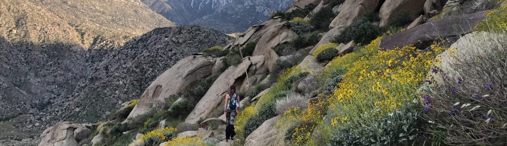
With maps in hand and backpacks stuffed to the brim, our starting point was the Indian Kitchen Trail Head. My backpack felt dreadfully uncomfortable almost immediately . The straps dug into my hips, my shoulders ached, and I couldn’t help but hunch over. After adjusting the pack several times with minimal relief, I realized that I would just have to deal with it and get used to it.
 From Indian Kitchen, we hiked to Bowed Tree Crossing and then towards Natural Bridge. We were backpacking on equestrian trails, so we had to be on the constant lookout for horse poop. This totally reminded me of growing up in an Amish town and going for late night runs in the “buggy lanes”.
On the way to Natural Bridge, we temporarily lost our bearings and ended up on the outskirts of the wilderness area. This was pretty clear because there was a private residence visible in the distance.
After some uphill backtracking and pushing through uncut forests, we found our way back on the trail to Natural Bridge. It was perfect hiking weather – 60’s and cloudy – but the clouds were starting to roll in and the forecasted rain seemed to be approaching.
 The rain began almost as soon as we reached Natural Bridge. We took a couple pictures and contemplated our next move. Our next move was pretty much decided for us as the sprinkles turned into a torrential downpour. Fortunately, we had scoped out a couple decent spots to set up camp along the way and had one particular spot in mind. We frantically pulled the tent gear from our packs and set the tent up in record speed.
It was about 5:30pm, but we were confined to the tent for the rest of the evening due to the rain. Although we had hiked less than eight miles, I was definitely feeling the strain of my first backpacking trip already.
 We had packed several freeze-dried meals and used a Jet Boil Stove to make ourselves a hearty meal of Mountain House New Orleans Style Rice with Shrimp and Ham and Blueberry Cobbler. These were surprisingly delicious!
The remainder of the waking hours were spent reading iPads and playing a dice/card game called Pass the Pigs. Except for the occasional sound of a locomotive engine horn, the night was completely silent.
Although quite cold, the sun was shining the next morning when we awoke. Our attempts to dry out the tent and rain fly were pointless, so we shoved the wet materials into our packs and set off for a short hike to Secret Canyon. This was probably the most impressive and scenic spot along the whole trail. The canyons formed a sort of amphitheater that curved around a large space under an expansive forest area. If only we would have known about these cavern retreats during the previous day’s rain storm! What a great natural shelter these would have provided!
We had to retrace our steps from the previous day to get back to my parked Jeep. On our first day, we only saw one other person on the trail….an older local gentleman on his horse. We saw the same gentleman on our second day as well and he advised us that there was a group of equestrian travelers up ahead.
We encountered these travelers at Owl Bluff. Three generations of a family dressed up in cowboy hats and chaps were having lunch in the clearing when we arrived in the area.
“Are you lost?” one older gentleman asked with a laugh.
“No, not really” we replied. ” with map and compass clearly in sight.
“Good! ‘Cause we are!” the gentleman exclaimed with another hearty laugh.
Although they had the same map that we did, we pointed out the path that we had traveled from and the approximate distances. They still seemed a bit uncertain, but were satisfied enough with our advice to wish us on our way. As we parted, one of the women cautioned us about a river up ahead and laughed about how we planned to get through it.
Although our hike was coming to an end, little did we know that one of the most challenging parts was still ahead. We’d already had to cross a few small creeks along the way, but with little difficulty. We’d take off our shoes, roll up our pants, and tip toe across the rocky creek bottom to get to the other side.
Our hiking boots squished down the trail from Owl Bluff, covered in mud and horse poop built up from the previous day’s rainstorm. As we came around a bend, we saw what the woman at Owl Bluff was laughing about. The river was probably five times as wide as the previous creeks we had crossed. The water was freezing cold, it was flowing at a moderate speed, and we couldn’t see the bottom. Mental notes were made about investing in waterproof hiking boots as soon as possible.
 There was no way around it, so we went through it. We moved slowly, cautiously, and with outstretched arms to avoid tipping over with the large backpacks and getting all of our supplies wet. After a good amount of time, we both finally reached the other side. At this point, we realized we were nearly out of drinking water. This wasn’t a huge deal because we only had a half day’s hike ahead of us. We had also packed some water purification tablets and wanted to test if they actually made natural water drinkable.
I scooped some yellow-brown water from the river that we had just crossed in our bare feet into my empty bottle and popped a couple tablets inside. The sun began to come out as we continued on the hike, and this provided to be yet another day with perfect hiking weather.
Without getting lost and with no additional obstacles (except for ample amounts of mud and horse poop), we made it back to the trail head. I was so relieved to see my blue Jeep in the distance. My first backpacking trip was complete and it was a success! Exhausted, I plopped down on the ground and checked the river water in my bottle. It was still yellow-brown. I dumped it out.
In total, we backpacked almost 20 miles. We prevailed through rainstorms, getting lost, trail-side cooking, river crossings, and each other during our hike. While beautiful, Shawnee National Forest was merely a baby-step in the direction of hardcore backpacking. Regardless, I learned a lot throughout this baby-step and I can’t wait to plan a teenager-step backpacking trip as soon as the winter passes.
Thanks for the information. I’m planning on a trip down to Shawnee National Forest in June, and Lusk Creek Wilderness is on the shortlist of possible backpacking locations. Somewhat surprisingly in this day and age, detailed online information on SNF and its wilderness areas is hard to come by, so I was happy to find your article.
Hi Zac,
Thanks for checking out my blog and so glad that you found the Shawnee information useful. I remember looking for good info about multi-day trips there awhile back and coming up short too. Hope you have an awesome time backpacking!
Cheers!
Alyssa
lThanks a ton, Alyssa, for the entertaining redition of your Shawnee adventure. I’m taking my 8 year old daughter there next week for the first time (my first in Shawnee too, tho I’ve done a good deal of trekking in the Western states) so it was good to read your blog & see your great pics, too. Thanks again.
Brian
Indianapolis
Hi Brian, thanks for checking out my blog! Hope you and your daughter had an amazing time in Shawnee. After spending the majority of my life in Illinois, I really think it is the best natural area for hiking, camping, and rock climbing. Cheers!
Thank you for this! I’m trying to plan a solo trip this month there. I’m from Chicago as well, and I’ve never been there. There’s NOTHING online that gives me any help with trail planning. So I guess I’m just gonna have to drive down there and get a map from the visitor center and plan from there! How much do the maps cost there?
Hi Matt! I’m not sure about the cost since it’s been a few years since I’ve been in that area. Hope you have an awesome adventure! Some great places to set up top ropes and climb around there too if you’re into that. Cheers!